IMD alerts as the storm intensifies over Bay of Bengal; heavy rainfall and strong winds are expected in Andhra Pradesh, Odisha, Tamil Nadu, and Gujarat.
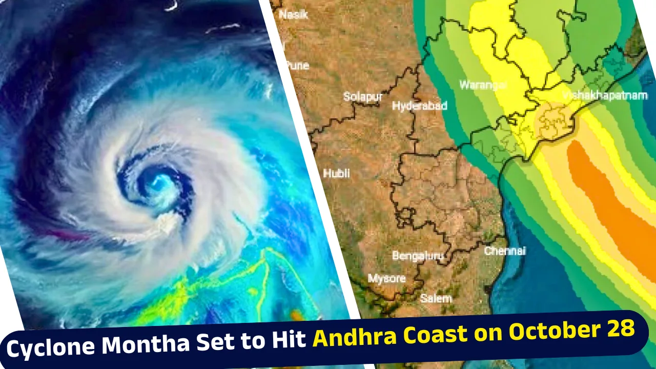
The India Meteorological Department (IMD) has warned that Cyclone Montha, forming over the Bay of Bengal, is expected to make landfall near Andhra Pradesh’s Kakinada coast on October 28, bringing heavy rainfall and winds reaching up to 110 km/h. As the system strengthens from a deep depression into a severe cyclonic storm, states along India’s eastern and southern coasts including Andhra Pradesh, Odisha, Tamil Nadu, and Gujarat are on high alert.
The storm, named Cyclone Montha by Thailand under the international naming convention, is currently moving west-northwestwards at about 10 km/h and is projected to intensify rapidly over the next 24 hours.
Key Updates on Cyclone Montha from IMD
- Cyclone Montha tracker: IMD confirmed that the deep depression over the southeast Bay of Bengal has intensified and is expected to become a severe cyclonic storm by October 28.
- Landfall prediction: The system is very likely to cross the Andhra Pradesh coast between Machilipatnam and Kalingapatnam, near Kakinada, between 5:30 pm and 11:30 pm on October 28.
- Wind intensity: At landfall, wind speeds may reach 90–100 km/h, gusting up to 110 km/h.
- Heavy rainfall alerts: IMD has issued orange and yellow warnings across Andhra Pradesh, Odisha, Tamil Nadu, and parts of Gujarat.
- Two active systems: Alongside the Bay of Bengal depression, another system is active over the east-central Arabian Sea, moving westward at 7 km/h.
Andhra Pradesh Braces for Cyclone Montha’s Impact
The Andhra Pradesh government has initiated a comprehensive action plan to mitigate the effects of Cyclone Montha. Civil Supplies Minister N. Manohar stated that preparations include positioning essential Public Distribution System (PDS) commodities, fuel management, food supplies for shelters, paddy procurement steps, and relief distribution post-landfall.
Disaster management teams have been placed on high alert across coastal districts, while fishermen have been advised not to venture into the sea. The IMD-Amaravati centre has warned of squally winds between 45 and 55 km/h, gusting to 65 km/h along and off the coast on October 26.
From October 27–29, heavy to extremely heavy rainfall is forecast in parts of Rayalaseema and Yanam, with storm surges likely to inundate low-lying areas near Kakinada and Visakhapatnam.
Odisha on Alert: Red Warning for Seven Districts
Neighbouring Odisha is also expected to face the storm’s impact between October 28 and 29, with heavy to very heavy rain predicted in Ganjam, Gajapati, Rayagada, Koraput, Malkangiri, Kalahandi, and Nabarangpur.
The IMD has issued a red alert for these seven districts and a yellow warning for nine others. Wind speeds could rise to 100–110 km/h, causing potential damage to infrastructure and crops.
Revenue and Disaster Management Minister Suresh Pujari held a high-level meeting with collectors from 15 districts, directing them to intensify evacuation and relief operations. Cyclone shelters have been readied, and government employees’ leaves have been cancelled in vulnerable regions to ensure immediate response.
As per the cyclone tracker, the system was centred 970 km southeast of Kakinada and 1030 km south-southeast of Gopalpur as of Saturday, continuing to move northwestward.
Heavy Rainfall Predicted in Tamil Nadu and Puducherry
The Regional Meteorological Centre (RMC) in Chennai has predicted moderate to heavy rainfall across Tamil Nadu and Puducherry in the next 24 hours.
- October 25: Showers expected in Cuddalore, Villupuram, Chengalpattu, and Puducherry.
- October 26–27: Chennai, Kancheepuram, Tiruvallur, Ranipet, and Vellore to witness intense rainfall.
- October 28: Rainfall may ease slightly, remaining heavy mainly in Tiruvallur and Ranipet districts.
Thunderstorms and lightning are likely at isolated places, with winds up to 40–50 km/h. The IMD has advised citizens to stay indoors during heavy spells and avoid low-lying flood-prone areas.
Gujarat Weather Update: Heavy Rain with Thunderstorms
Although Cyclone Montha’s landfall is predicted along the east coast, Gujarat is also expected to receive heavy rainfall due to associated weather systems.
Also Read: IMD Issues Heavy Rain Alert for 5 States Till October 28; Delhi to Stay Sunny and Dry
The IMD reported that Amreli, Gir Somnath, and Diu districts may receive over 15 mm rainfall per hour, accompanied by surface winds of 41–61 km/h and a moderate risk of lightning.
Other districts Junagadh, Bhavnagar, Bharuch, Narmada, Surat, Tapi, Dangs, Navsari, Valsad, Daman, and Dadra & Nagar Haveli are likely to see moderate rainfall and light thunderstorms.
Second Weather System Active Over Arabian Sea
Alongside Cyclone Montha, another depression over the east-central Arabian Sea continues to move westward at about 7 km/h.
At 5:30 am on October 26, it was located approximately 700 km west-southwest of Mumbai and 760 km west of Panjim, with IMD predicting continued westward movement over the next 24 hours.
Although this system poses no immediate threat to India’s west coast, its interaction with Montha could influence wind and rainfall patterns across peninsular India.
Preparedness and Public Safety
Both central and state authorities have activated emergency control rooms, with the National Disaster Response Force (NDRF) and State Disaster Response Forces (SDRF) on standby.
Citizens are being urged to follow IMD advisories, stock up on essential supplies, and stay tuned to official updates on the Cyclone Montha tracker.
Fishing operations in the Bay of Bengal and the Arabian Sea have been suspended until further notice.
Severe Cyclonic Storm to Test Coastal Preparedness
As Cyclone Montha intensifies and approaches the Andhra coast, it is set to test the preparedness and resilience of India’s coastal states. With red and orange alerts in place, strong winds and torrential rain could disrupt transportation, agriculture, and power lines in several regions.
Authorities are urging people not to panic but to stay alert. The IMD continues to monitor the cyclone’s trajectory using advanced cyclone trackers and satellite models to provide timely updates.
The next 24–48 hours will be crucial in determining the final intensity and landfall impact of Cyclone Montha on India’s eastern coastline.
How Saint Rampal Ji Maharaj Ji’s Eternal Knowledge Protects Humanity from Calamities
We live in a world filled with challenges due to human mistakes, where even devotion to deities cannot always shield us from suffering. Tatvdarshi Sant Rampal Ji Maharaj, the current complete incarnation of Kabir Paramatma, explains through His divine discourses and authentic scriptures how humans have arrived in this state and why true protection lies only in following the complete knowledge revealed by God.
Even during natural calamities, like floods in Punjab and Chhattisgarh, Tatvdarshi Sant Rampal Ji Maharaj Ji has actively helped millions, distributing aid worth thousands of crores from jail premises. This is not a myth but the continuation of the same divine leelas performed by Kabir Paramatma centuries ago, now manifested in Tatvdarshi Sant Rampal Ji Maharaj Ji. By sincerely listening to His satsang, anyone can achieve spiritual welfare and protection from worldly hardships.
FAQs on Cyclone Montha
1. What is Cyclone Montha and when will it make landfall?
Cyclone Montha is a severe storm over the Bay of Bengal, expected to hit Andhra Pradesh near Kakinada on October 28 with heavy rain and strong winds.
2. Which areas are most affected by Cyclone Montha?
Andhra Pradesh, Odisha, Tamil Nadu, and parts of Gujarat are on high alert, with heavy rainfall, strong winds, and possible coastal flooding.
3. How fast is Cyclone Montha moving?
The storm is moving west-northwest at around 10 km/h, while a separate Arabian Sea depression moves west at 7 km/h.
4. What precautions should people take for Cyclone Montha?
Stay indoors, avoid low-lying areas, follow IMD alerts, stock essential supplies, and monitor the Cyclone Montha tracker for live updates.
5. What are the wind speeds and rainfall expected from Cyclone Montha?
Winds may reach 90–110 km/h, with heavy to extremely heavy rainfall across Andhra Pradesh, Odisha, Tamil Nadu, and parts of Gujarat.