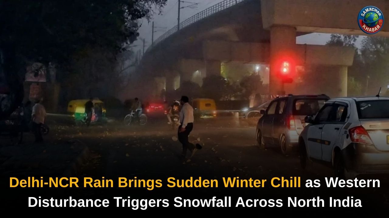
A significant weather change is unfolding across North India as an active western disturbance impacts the plains and hill regions alike. Delhi-NCR witnessed rain, thunderstorms and gusty winds on Friday, bringing an end to a prolonged dry spell and causing temperatures to drop sharply after the warmest January day in seven years.
The India Meteorological Department has issued yellow and orange alerts across several regions, warning of rainfall, lightning, hailstorms and strong winds. Meanwhile, heavy snowfall is forecast in Jammu & Kashmir, Himachal Pradesh and Uttarakhand, raising concerns over travel disruption, landslides and reduced visibility in mountainous areas.
Key Weather Updates Across North India Due to Western Disturbance
- Active Western Disturbance triggers rain, thunderstorms and snowfall across North India
- Delhi-NCR sees rainfall and gusty winds, ending a prolonged dry spell
- Temperatures drop sharply after Delhi records warmest January day in seven years
- Air quality shows marginal improvement but remains in poor to very poor category
- Heavy snowfall alerts issued for Jammu & Kashmir, Himachal Pradesh and Uttarakhand
- Dense fog and cold wave conditions persist across Indo-Gangetic plains
Rain and Thunderstorms Affect Delhi-NCR as Weather Turns Unsettled
Several parts of Delhi and the National Capital Region experienced light to moderate rainfall accompanied by thunderstorms on Friday morning as weather conditions shifted rapidly. According to the India Meteorological Department, an active western disturbance is influencing the region, bringing cloudy skies, rain, lightning and gusty winds.
Wind speeds of 30 to 40 kmph were reported during the early morning to forenoon hours, with gusts touching up to 60 kmph at isolated locations. At 4:30 am, gusty winds of 37 kmph were recorded at Delhi’s IGI Airport, Palam. Shallow fog was also observed in the morning hours, affecting visibility in some areas.
Areas in Delhi and NCR Likely to Be Affected
The weather department indicated that several areas of Delhi were impacted by rain and thunderstorms, including Rohini, Dwarka, Nazafgarh, Rajouri Garden, Narela, Bawana, Alipur, Burari, Kanjhawala, Model Town, Azadpur, Pitampura, Mundaka, Paschim Vihar, Punjabi Bagh and Jafarpur.
In the National Capital Region, similar weather conditions were reported in Noida, Gurugram and Bahadurgarh, while adjoining areas of Haryana and Rajasthan, including Rohtak, Jhajjar, Farukhnagar, Mahendargarh and Kotputli, were also placed under weather warnings.
From Warmest January Day to Sudden Chill in Delhi
Just a day before the rain, Delhi experienced unusually warm weather. On Thursday, the maximum temperature at the Safdarjung observatory reached 27.1 degrees Celsius, making it the warmest January day in the last seven years. Weather officials attributed the spike to warm easterly winds and clear skies that led to longer sunshine hours.

However, with cloud cover and rainfall setting in, temperatures dropped sharply. The maximum temperature in Delhi is expected to remain between 18 and 20 degrees Celsius on Friday, while the minimum is likely to settle around 12 degrees Celsius. Further cooling is expected over the weekend, with temperatures forecast to dip to 16–18 degrees Celsius.
Rain Brings Limited Relief as Air Quality Remains Poor
Rainfall and increased wind speed brought marginal improvement in air quality across the national capital, but pollution levels remained a concern. Data from the Central Pollution Control Board showed Delhi’s 24-hour average Air Quality Index hovering between 297 and 313, placing it in the ‘poor’ to ‘very poor’ category.
Station-wise data indicated high pollution levels in areas such as Wazirpur, Ashok Vihar, Bawana, Punjabi Bagh, Chandni Chowk, RK Puram, Anand Vihar and Dwarka Sector 8. Noida and Gurugram recorded slightly better air quality but continued to remain in the ‘poor’ category.
The Commission for Air Quality Management revoked Stage III of the Graded Response Action Plan across Delhi-NCR, citing improvement in overall air quality, while measures under Stages I and II remain in force. Forecasts by the Air Quality and Weather Forecasting System suggest air quality may remain moderate on January 23 and 24 before slipping back to the poor category on January 25.
Snowfall Intensifies Across Jammu & Kashmir and Himachal Pradesh
While rainfall affected the plains, the impact of the western disturbance intensified in the hill states. The IMD forecast widespread rain and snowfall across Jammu & Kashmir, Ladakh, Himachal Pradesh and Uttarakhand.
In the Kashmir Valley and Pir Panjal region, moderate to heavy snowfall is expected, with high-altitude areas such as Zojila Pass, Gulmarg and parts of Kupwara likely to receive two to three feet of snow. Authorities warned that snowfall could disrupt road connectivity, trigger landslides and affect air services.
Also Read: Delhi Chokes Under Severe Smog as GRAP IV Curbs Kick In, Schools on Online Mode Alert
As a precaution, officials in Kulgam district said that pregnant women nearing delivery had been shifted to hospitals. Rain was also reported in parts of Jammu city, intensifying cold wave conditions.
Orange and Yellow Alerts Issued in Uttarakhand and Himachal
The IMD issued orange alerts for heavy rainfall and snowfall in Uttarakhand districts including Uttarkashi, Rudraprayag, Chamoli, Bageshwar and Pithoragarh. Yellow alerts were issued for Dehradun, Tehri, Haridwar, Pauri, Almora and Nainital due to the possibility of hailstorms and strong winds.
In Himachal Pradesh, orange alerts were issued for heavy snowfall in districts such as Chamba, Kullu and Lahaul-Spiti. Snowfall was reported in Shimla and Manali, ending a prolonged dry spell. The Shimla administration issued advisories urging people to avoid unnecessary travel until weather conditions improve.
Dense Fog and Cold Wave Conditions Continue
Despite rainfall, cold waves and dense fog conditions are expected to persist across the Indo-Gangetic plains. Dense fog is likely to form during early morning and night hours in parts of Delhi-NCR, Haryana, Punjab and Chandigarh, potentially affecting road, rail and air traffic.
Motorists and commuters have been advised to drive cautiously, use fog lamps where required and stay updated with official weather advisories as conditions remain volatile.
Spiritual Perspective: Understanding Nature and Human Responsibility Through the Teachings of Saint Rampal Ji Maharaj
Amid frequent weather disturbances, natural calamities and environmental imbalance, the spiritual teachings of Saint Rampal Ji Maharaj offer a reflective perspective on humanity’s relationship with nature. According to his unique spiritual knowledge, nature operates under divine laws, and repeated disturbances are reminders for humans to adopt a disciplined, righteous and compassionate way of living.
He emphasises that unchecked materialism, violence and disregard for moral conduct disturb natural harmony. Saint Rampal Ji Maharaj advocates a life based on true spiritual understanding, ethical living and devotion, stating that inner transformation and collective responsibility are essential for restoring balance between humanity and nature.
What This Weather Change Signals for the Region
The ongoing western disturbance has brought much-needed rain to Delhi-NCR and snowfall to the Himalayan states, marking a decisive shift in North India’s winter weather. While rainfall may offer temporary relief from pollution, fluctuating temperatures, dense fog and snowfall-related disruptions are expected to continue in the coming days.
Authorities have urged residents to remain alert, follow advisories and avoid unnecessary travel in vulnerable areas as the system continues to influence weather patterns across the region.
FAQs on Major Weather Shift Across North India Due to Western Disturbance
1. Why is Delhi-NCR experiencing rain and thunderstorms today?
Delhi-NCR is witnessing rain and thunderstorms due to an active western disturbance bringing cloud cover, gusty winds and precipitation across North India.
2. What caused the sudden temperature drop in Delhi after warm weather?
Rainfall, cloud cover and shifting wind patterns following a western disturbance caused temperatures to drop sharply after Delhi recorded its warmest January day in seven years.
3. Which Himalayan states are under snowfall alert?
Jammu & Kashmir, Himachal Pradesh and Uttarakhand are under yellow and orange alerts for rain, snowfall, hailstorms and strong winds.
4. Has air quality improved in Delhi due to rain?
Rain and wind brought marginal improvement, but Delhi’s air quality continues to remain in the poor to very poor category, according to official data.
5. Will fog and cold wave conditions continue in North India?
Yes, dense fog and cold wave conditions are expected to persist across Delhi-NCR and the Indo-Gangetic plains, especially during early morning and night hours.