A rare and unusually early Sudden Stratospheric Warming (SSW) event is unfolding high above the Arctic, triggering an alarming weakening of the polar vortex and raising global concern ahead of winter. Forecast models from the Met Office, NOAA, and leading climate researchers suggest that this rapid stratospheric warming—nearly unprecedented for November—is poised to reshape weather across the Northern Hemisphere in the coming weeks.
With winds around the polar vortex collapsing and possibly reversing, regions including the UK, US, Europe, and parts of Asia may face colder-than-average conditions, heightened snow risks, and significant early-winter weather shifts.
Key Takeaways on the Historic Sudden Stratospheric Warming and Polar Vortex Shifts
Historic Early-Season SSW Developing
Forecasts show an exceptionally rare November stratospheric warming event—one of the earliest significant disruptions seen in the satellite era.
Polar Vortex Weakening Raises Global Concern
Rapid warming may weaken or reverse vortex winds, increasing chances of Arctic cold spilling into the UK, US, Europe, and Asia.
Cold Risks Rise 10–14 Days After SSW
Models indicate the UK and many regions could feel colder-than-average conditions within two weeks of the warming peak.
Past SSWs Triggered Severe Cold Events
Similar disruptions led to the 2014 polar vortex outbreak, the 2021 Texas freeze, and the 2018 Beast from the East in the UK.
Forecast Challenges Grow Amid Satellite Data Loss
Experts warn that diminishing stratospheric satellite data is making forecasts harder, increasing uncertainty in winter projections.
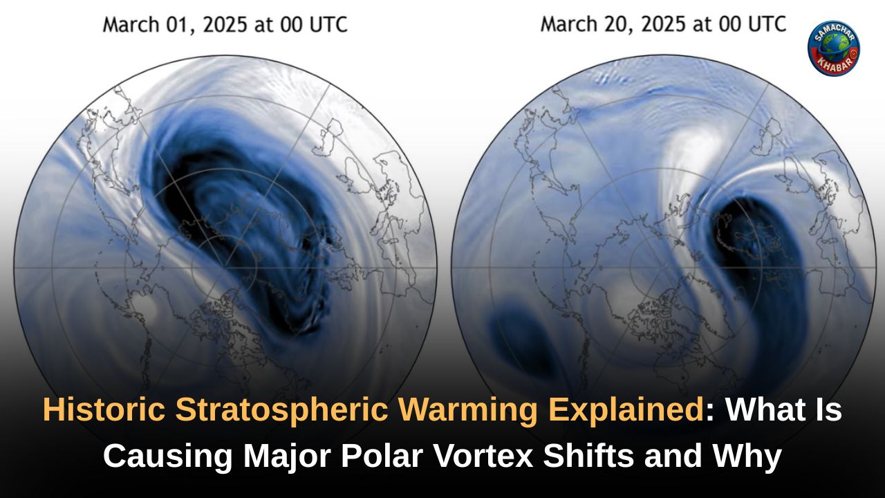
A Rare and Rapid Atmospheric Shift Raises Alarms Worldwide
A dramatic transformation is unfolding high above the North Pole, where temperatures in the stratosphere—normally bitterly cold—are rising at an extraordinary rate. This rapid warming is a classic signature of Sudden Stratospheric Warming, a powerful atmospheric phenomenon capable of reshaping winter weather across vast regions.
Meteorologists from the Met Office and NOAA confirm that the polar vortex, which typically traps cold air over the Arctic, is showing signs of weakening and may even reverse direction. Such early-season weakening is extremely rare, and scientists caution that its consequences could be far-reaching.
What Is Sudden Stratospheric Warming and Why Does It Matter?
Sudden Stratospheric Warming occurs between 10 km and 50 km above Earth’s surface when atmospheric waves push warm air upward into the stratosphere. This process disrupts the Polar Night Jet—strong westerly winds that encircle the Arctic in winter.
When these westerlies weaken or reverse, the stratosphere rapidly warms as air compresses over the polar region. This disruption can propagate downward into the troposphere over days or weeks, altering jet stream patterns and shifting storm tracks across the Northern Hemisphere.
Although the stratosphere is usually stable, these events can unleash powerful changes in surface weather, including intense cold spells and snow outbreaks.
Why This November SSW Is Drawing Global Attention
Experts emphasize that the timing of this event is extremely unusual. According to NOAA scientist Dr. Amy Butler, major stratospheric warmings in November are almost unheard of, with only one to two such events documented since 1958. MIT climatologist Dr. Judah Cohen describes this early-season disruption as “unprecedented,” noting the lack of historical analogs to help predict outcomes.
Forecast models show stratospheric temperatures climbing by 20 to 25°C—an enormous jump by atmospheric standards—alongside signs of polar vortex winds collapsing toward zero and potentially reversing. This sets the stage for heightened winter volatility across the Northern Hemisphere.
Potential Weather Shifts in the United States
NOAA’s Climate Prediction Center reports increased odds of below-average temperatures across central and eastern US during late November and December.
Regions like the Northern Plains, Midwest, and East Coast are especially vulnerable to polar air outbreaks. Past SSW-driven events triggered some of the most extreme cold in recent history, including the 2014 polar vortex crisis and the 2021 Texas freeze.
However, forecasters stress that not every SSW guarantees snow. The outcome depends on where the jet stream dips and how far south Arctic air travels.
California’s Early December Outlook
California, unlike the eastern US, may see quieter early-December weather.
Historical patterns—especially the November–December 2000 SSW—suggest a ridge of high pressure often forms over the West Coast during such disruptions, limiting storms and keeping conditions mild.
Yet, meteorologists caution that weak La Niña conditions and future atmospheric river developments may still shape California’s later-December weather.
How the UK and Europe Could Be Affected
The Met Office warns that an SSW can force the jet stream southward, allowing easterly winds to bring much colder continental air into the UK.
This shift increases the likelihood of:
- Snowfall and wintry precipitation
- Colder-than-average temperatures
- High-pressure blocking over the North Atlantic
- Reduced inflow of mild Atlantic air
While not all SSWs lead to severe cold, around 70% of events correlate with cold snaps in the UK, including the 2018 Beast from the East, which buried parts of Britain under 20 inches of snow.
Forecasting Challenges Amid Declining Satellite Data
Meteorologist Andrea Lopez Lang warns that forecasting SSWs is becoming more difficult as key stratospheric satellite instruments age or go offline.
These observations are essential for tracking wind reversals, temperature spikes, and polar vortex displacement. Losing this data increases the uncertainty surrounding long-range winter forecasts.
Understanding Nature’s Signals Through the Divine Knowledge of Saint Rampal Ji Maharaj Ji
In times when rare atmospheric events raise global uncertainty, Saint Rampal Ji Maharaj explains through His unique spiritual knowledge that nature operates under the supreme authority of the Almighty God, and every shift in the universe reflects His power. According to the eternal wisdom revealed in the sacred scripture-based teachings of Saint Rampal Ji Maharaj, true peace and protection come only when humanity reconnects with the Supreme God through the correct way of worship.
As the world experiences unpredictable climate patterns, His guidance reminds us that only divine wisdom can bring stability, inner strength, and a deeper understanding of nature’s workings.
A Critical Atmospheric Turning Point for the Winter Ahead
This unusually early Sudden Stratospheric Warming marks a significant shift in atmospheric dynamics as winter approaches. While extreme cold is not guaranteed, the weakening polar vortex dramatically increases the risk of colder-than-average conditions and snowier periods across the Northern Hemisphere.
California may begin December quietly, while the UK, US, and parts of Europe remain on alert for potential cold outbreaks. As the stratospheric disruption unfolds over the next several weeks, the global weather pattern is poised for notable and potentially historic winter shifts.
FAQs on Historic Sudden Stratospheric Warming and Polar Vortex Shifts
1. What is Sudden Stratospheric Warming and why is it significant?
Sudden Stratospheric Warming is a rapid temperature spike in the stratosphere that weakens the polar vortex, increasing the risk of severe winter cold across multiple regions.
2. How will the current SSW impact winter weather in the UK?
The UK may face colder-than-average conditions, a southward-shifted jet stream, and increased chances of snow due to weakened westerlies after the SSW event.
3. Could the SSW trigger extreme cold in the United States?
Yes. Models show higher chances of Arctic outbreaks affecting the Northern Plains, Midwest, and East Coast, similar to past polar vortex disruptions.
4. Why is this SSW considered historically unusual?
Because major SSW events in November are extremely rare, with only a few recorded since the satellite era began in the 1960s.
5. Will California experience severe winter weather from this SSW?
Early December may remain mild for California, though later conditions depend on jet-stream shifts, La Niña patterns, and atmospheric river activity.