The UK may be heading towards a significant winter weather shift as meteorologists warn that a rare Sudden Stratospheric Warming (SSW) event—similar to the one that triggered the 2018 “Beast from the East”—is developing unusually early this season. After a week of sub-zero temperatures, snow, and widespread ice warnings, the Met Office confirms that signs of a minor SSW are emerging in the upper atmosphere.
While milder Atlantic conditions briefly returned over the weekend, early modelling suggests the potential for a renewed cold blast over the next two weeks, raising the possibility of severe wintry conditions across the country.
Key Takeaways on Sudden Stratospheric Warming and UK Winter Forecast
- The Met Office confirms indications of a minor SSW developing unusually early in the season.
- SSW events increase the likelihood of a UK cold snap by nearly 70% within 10–14 days.
- The same phenomenon triggered the 2018 Beast from the East, which brought extreme snowfall and temperatures of –14.7°C.
- Current Arctic air has already pushed temperatures to –12.6°C and –11.7°C in parts of Scotland this week.
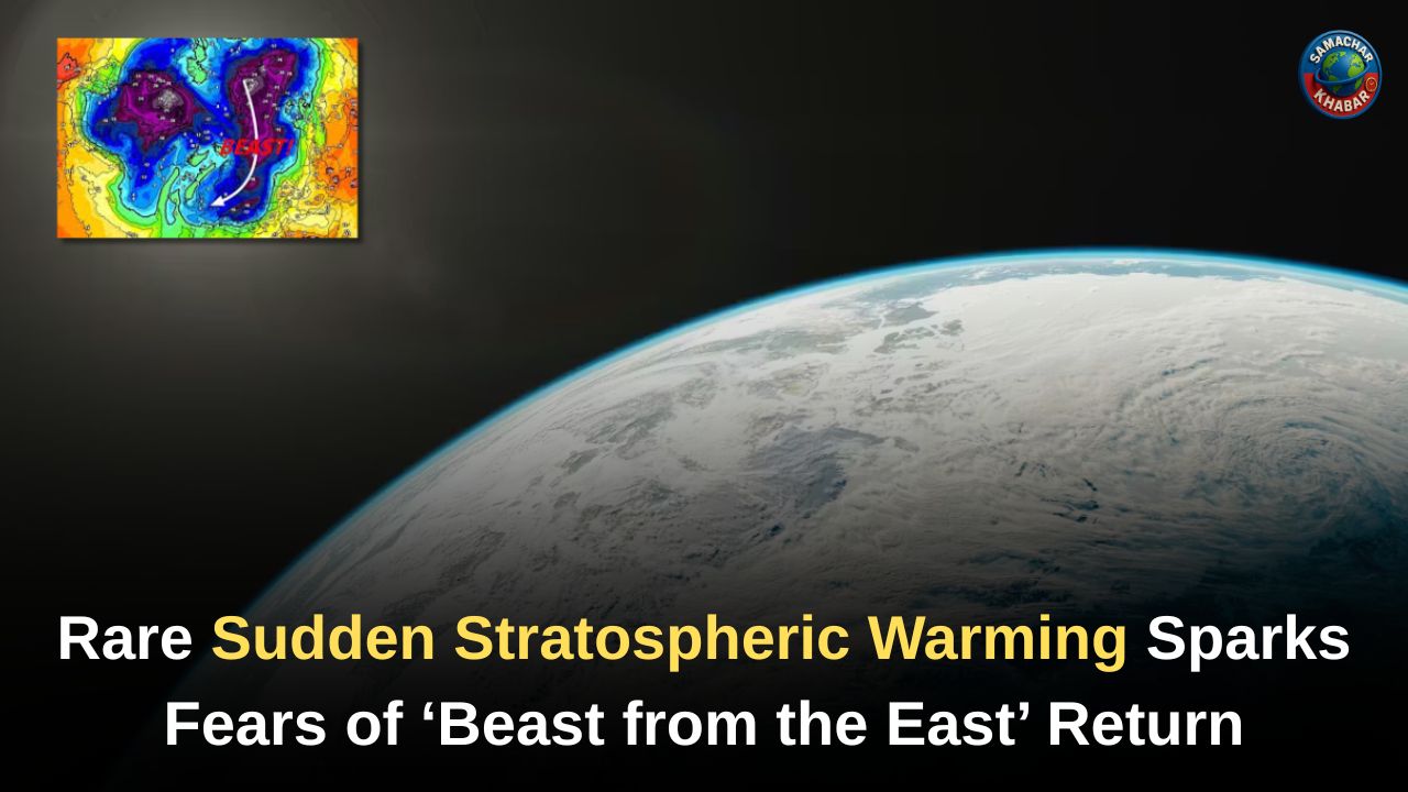
- Forecast models show the polar vortex winds weakening or reversing—an early signal of an SSW.
- Meteorologists caution that not every SSW leads to extreme cold, but it dramatically raises winter weather risks.
- Some analyses suggest this SSW could be a reflective type, which may bring unsettled and mild Atlantic-driven weather before any potential cold spell.
- The Madden–Julian Oscillation (MJO) may later encourage high-pressure blocking, possibly shifting Europe towards colder weather mid-December.
What Is Sudden Stratospheric Warming and Why Does It Matter?
Sudden Stratospheric Warming refers to a dramatic rise in temperatures—sometimes by 50°C within days—in the stratosphere, located 10 to 50 km above Earth. Though this warming occurs far above the surface, its impact on ground-level weather can be immense.
At the heart of SSW is the Polar Night Jet, a fast-moving band of westerly winds encircling the Arctic. Disturbances in the lower atmosphere, often linked to large high-pressure systems, can destabilize this jet. These disturbances produce atmospheric waves that travel upward and break in the stratosphere, weakening or even reversing the Polar Night Jet.
As this disruption forces air to collapse downward, it compresses and rapidly warms the stratosphere. This shift changes the direction of upper-level winds, pulling them from the east instead of the west. Once these wind changes descend into the troposphere—where everyday weather occurs—they can dramatically alter the UK’s weather patterns.
How an SSW Impacts UK Weather: The Science Behind the Cold
The UK’s typical winter setup involves mild, moist Atlantic winds arriving from the west. But an SSW can completely reshape this flow.
When the stratospheric winds reverse:
- The jet stream is pushed farther south.
- High pressure can build over the North Atlantic.
- The usual Atlantic air is blocked.
- Cold continental air from Europe and Siberia can sweep into the UK.
This exact pattern drove the infamous 2018 Beast from the East, delivering unprecedented snowfall—up to 50 cm in some areas—along with temperatures plunging as low as –14.7°C.
While not all SSW events create extreme cold, historical data shows that around 70% of them are followed by significant cold spells across northern Europe and the UK.
Early Signals: What Meteorologists Are Seeing Now
Met Office meteorologist Aidan McGivern revealed that most weather models now indicate the winds surrounding the polar vortex could reverse by late November or early December—a clear sign of an SSW.
He emphasized two key points:
- It is unusually early in the winter for such an event.
- A cold snap is not guaranteed, but the risk is significantly elevated.
The UK is already experiencing the effects of Arctic air masses. This week alone saw temperatures of –12.6°C in Scotland, while Loch Glascarnoch recorded –11.7°C, marking the coldest night of the season so far. Snowfall led to school closures, and multiple yellow and amber warnings were issued across the country.
Reflective vs Absorbing SSW: What Type Is Forming Now?
Some advanced analyses indicate that the current SSW may be a reflective type—different from the absorbing SSW linked to the 2018 Beast from the East.
Reflective SSW Characteristics
- Planetary waves bounce back toward the troposphere.
- The warming episode is cut short.
- Strong westerly winds may re-strengthen.
- UK weather may turn mild, unsettled, and stormy rather than bitterly cold.
This pattern could trigger:
- Stronger Atlantic jet stream
- Windy spells
- Mild southwesterly flows
- Potential early-December storms, possibly even named storms
Absorbing SSW Characteristics (2018 Example)
- Planetary waves are absorbed in the stratosphere
- Polar vortex collapses
- Easterly winds descend
- High-latitude blocking forms
- Cold Arctic air surges across Europe and UK
Forecasters stress that while current signs lean toward a reflective SSW, conditions may evolve.
A Look at December: Could Colder Weather Still Return?
Despite the possibility of mild, unsettled weather in early December, not all long-range signals point to a warm month.
The Madden Julian Oscillation (MJO), currently moving toward Phase 7, could shift rainfall patterns in the western Pacific. Historically, this leads to:
- Stronger northern European blocking
- Colder, drier weather 2–3 weeks later
- Increased chance of snow outbreaks
This suggests that mid-December onward may carry a renewed risk of cold spells, even if early December is dominated by Atlantic-driven mildness.
However, if the stratospheric and tropospheric polar vortex re-couple, the UK may instead face persistent strong westerlies, resulting in stormy, wet, and mild weather through much of December.
Meteorologists caution that uncertainty remains high.
Climate Signals: What Long-Term Data Suggests
SSW events may be linked to climate change, but the relationship is still poorly understood. Research offers mixed signals:
- The UK now experiences 20% fewer days of ground frost compared to 1961–1990.
- Yet parts of Eurasia have recorded an increase in cold spells over the past decade.
Scientists emphasize that while cold extremes may generally decrease, regional variations will continue.
Understanding Nature’s Signals Through the Unique Spiritual Knowledge
As the UK watches unusual atmospheric changes like Sudden Stratospheric Warming and shifting global weather patterns, many reflect on the deeper forces influencing nature. Saint Rampal Ji Maharaj explains through His spiritual discourses that natural events serve as reminders of the Supreme Power governing the universe. His teachings emphasise that true stability—whether in human life or the world around us—comes only from understanding the eternal laws set by the Almighty.
By adopting the scripturally-backed devotion revealed by Saint Rampal Ji Maharaj, followers believe one can attain peace, protection, and a deeper awareness of nature’s functioning. In times of uncertainty, these insights offer a reassuring spiritual perspective.
Shifting Patterns Ahead: What the UK Should Expect Now
As the UK moves deeper into winter, the atmosphere is clearly undergoing significant shifts. Early signs of Sudden Stratospheric Warming, combined with ongoing Arctic air incursions and evolving tropical patterns, signal a highly changeable and unpredictable start to the season. While immediate conditions may trend milder and unsettled due to a potentially reflective SSW, the risk of renewed cold increases again toward mid-December.
With meteorologists carefully monitoring stratospheric developments, the coming weeks will determine whether the UK faces a winter of stormy Atlantic weather or a return of the notorious Beast from the East.
FAQs on Sudden Stratospheric Warming and the UK’s Winter Forecast
1. What is Sudden Stratospheric Warming (SSW)?
SSW is a rapid temperature rise in the stratosphere that weakens or reverses polar vortex winds, increasing the chance of cold snaps in the UK.
2. Can SSW trigger another Beast from the East in the UK?
Yes. SSW caused the 2018 Beast from the East. Current models show early signs of SSW, raising the risk of cold easterly winds reaching the UK.
3. How soon could the UK feel the effects of an SSW?
The UK usually experiences potential impacts 10–14 days after an SSW develops, depending on wind direction and how the event evolves.
4. Will this SSW definitely bring extreme cold weather?
Not guaranteed. Around 70% of SSW events lead to cold spells, but this one may initially bring unsettled, mild Atlantic conditions if reflective.
5. What weather changes has the UK already experienced this week?
The UK faced Arctic air, snow, ice warnings, and temperatures as low as –12.6°C and –11.7°C, with some schools closing due to severe wintry conditions.