The Atlantic hurricane season continues to churn, and the latest system to earn a name is Tropical Storm Jerry. Formed on Tuesday, October 7, in the central Atlantic Ocean, Jerry quickly became the tenth named storm of the active 2025 season. As a large area of showers and thunderstorms coalesced into an organized system far from land, meteorologists and coastal residents alike turned their attention to its rapidly developing track.
The crucial question on everyone’s mind is: Where exactly is this new tropical storm headed, and how intense will it become? Early indications and computer model projections offer a clearer picture, suggesting that while the Caribbean should monitor its progress closely, the mainland United States may be spared a direct impact from Tropical Storm Jerry.
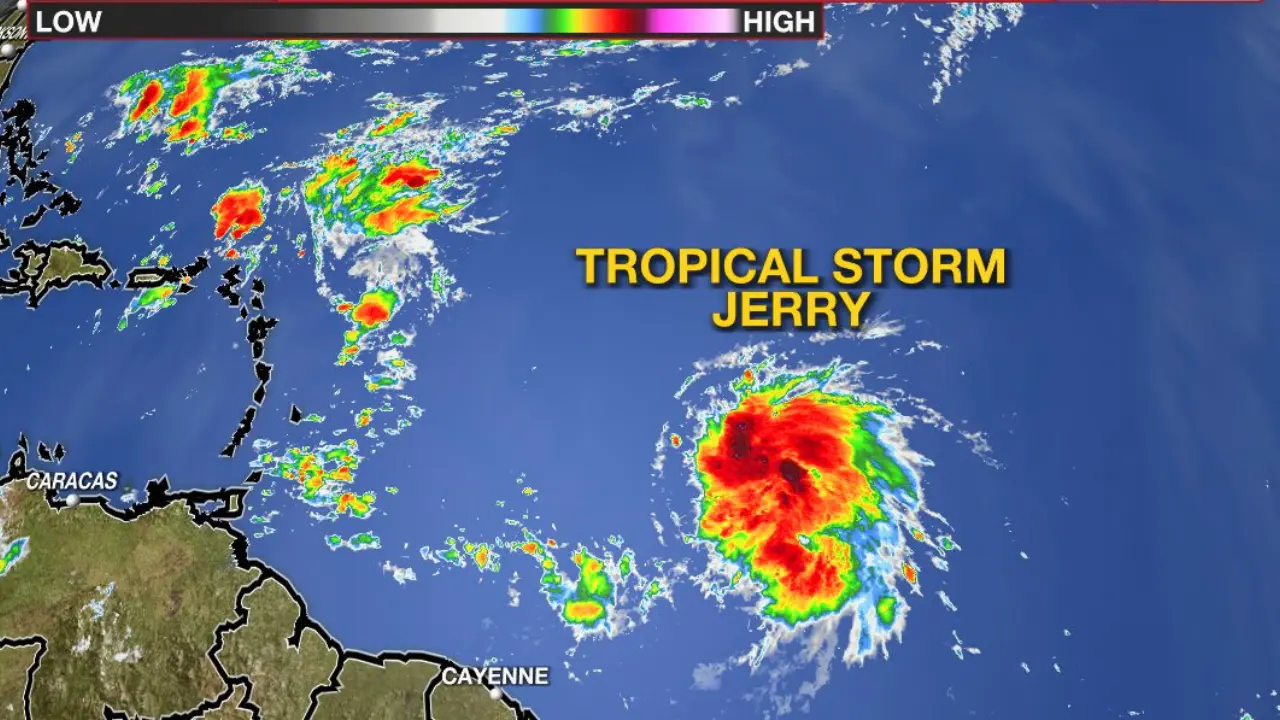
Current Status and Rapid Development of Tropical Storm Jerry
As of the latest advisories, Tropical Storm Jerry is located in the Central Atlantic and is moving briskly to the west-northwest. The storm is in an environment favorable for further strengthening, leading to a high probability that it will achieve hurricane status in the coming days.
Here are the key metrics from the National Hurricane Center (NHC) as of Tuesday, October 7:
- Classification: Tropical Storm
- Maximum Sustained Winds: 45 mph
- Movement: West at 24 mph
- Location: Central Atlantic Ocean, approximately 1,500 miles east of the Windward Islands.
- Next Expected Intensity: Expected to become a hurricane as early as late this week.
This rapid development is a stark reminder that even as the season progresses into October, the tropical Atlantic remains a fertile ground for intense storms.
The Forecasted Track: A Curve Away from the U.S.
The most critical part of any tropical system forecast is the track—where the steering currents in the atmosphere will take the storm. For Tropical Storm Jerry, the consensus among weather models is encouraging for the U.S. East Coast, but it demands immediate vigilance for the Caribbean islands.
Near-Term Threat: The Northern Leeward Islands
The immediate threat lies with the northern Leeward Islands. The current forecast path projects that Tropical Storm Jerry will track near or just north of this island chain by late Thursday into Friday.
Expected Impacts:
- Heavy rain
- Gusty winds
- Rough seas and dangerous surf
- Elevated risk of rip currents
Residents of the northern Leeward Islands, including areas like Antigua, St. Kitts, and Nevis, should ensure their preparedness plans are in place. The exact track—a slight shift north or south—will determine the severity of the impacts for each island. Puerto Rico and the Virgin Islands should also monitor the storm’s progress closely, as a slower northward turn could bring more significant rainfall and wind.
Long-Range Trajectory: The All-Important Northward Turn
The factor most likely to steer Tropical Storm Jerry away from the mainland U.S. is a “dip” in the jet stream or a developing trough of low pressure in the eastern US. Meteorologists anticipate that this feature, positioned near the Southeast coast later this week, will act as a “steering wheel,” successfully turning Jerry to the northwest, then north, and finally northeast—safely pushing it out to sea over the open Atlantic.
Also Read: Florida Tropical Storm Watch: Imelda Impacts & Safety
Original Insight: This expected turn, known as a ‘recurve,’ is a classic meteorological phenomenon common for storms that reach this part of the Atlantic in October. While some models initially showed a track closer to the U.S. coast, the high confidence in the steering mechanism suggests that a curve out to sea, well east of Bermuda, is the most likely scenario. An AccuWeather spokesperson has already indicated that they expect Tropical Storm Jerry to have no direct U.S. impacts.
Why This Storm Still Matters
Even if the storm remains offshore, a developing hurricane in the central Atlantic has widespread implications:
- Marine Hazards: Shipping lanes and fishing grounds in the central and western Atlantic will experience significant wave action, high winds, and a prolonged period of hazardous conditions.
- Coastal Erosion and Rip Currents (Indirectly): Even a distant storm can whip up large swells that travel thousands of miles. This energy reaches shorelines as rough surf, dramatically increasing the risk of dangerous rip currents and exacerbating coastal erosion along the US East Coast.
- The Active Season: Tropical Storm Jerry forming in October reminds us that hurricane season officially runs until November 30. Historically, the season’s climatological peak activity is in mid-September, but late-season storms often form in the far eastern Atlantic and pose a significant risk as they travel across warm waters.
Statistic and Authority: For context on the season’s activity, based on the 30-year climate period from 1991 to 2020, an average Atlantic hurricane season produces 14 named storms. Jerry, the 10th named storm of the current season, shows that 2025 is following the path of an active period, underscoring the necessity of continued preparedness.
The Role of Steering Currents and the Bermuda High
To understand why tropical storms go where they go, we must look at the “Bermuda High”—a semi-permanent high-pressure system over the Atlantic. Its position and strength are the main factors that steer hurricanes.
When the Bermuda High is strong and dominates the Atlantic, it forces storms to track further west toward the Caribbean and the U.S. When the High is weaker or when a trough (like the one expected near the U.S. coast) is present, it creates a break in the high-pressure shield, allowing the storm to turn north and escape into the open ocean.
For Tropical Storm Jerry, the expected position of the frontal system should create a clear path for the northward escape, limiting its impact to a close call for the northeastern Caribbean islands.
Preparedness and Resources for Tropical Storm Jerry
While the U.S. coastline may breathe a sigh of relief, the time to prepare is always before a storm threatens. We encourage everyone, especially those in the Caribbean, to review their hurricane preparedness plans.
- Monitor Official Sources: Always rely on the latest forecasts from the NHC and your local meteorological service. (External link to Authority Source: National Hurricane Center – www.nhc.noaa.gov)
- Emergency Kit: Ensure your emergency kit is stocked with food, water, medicine, flashlights, and a battery-powered radio.
- Evacuation Routes: Know your local evacuation zones and routes if you are in a coastal area.
- Protect Property: Secure loose outdoor objects, trim back dead branches, and review your property’s flood and wind insurance policies. (Internal link suggestion: What to Include in Your Hurricane Emergency Kit)
- Stay Informed about Water Safety: Even with an offshore track, dangerous rip currents will be a concern along the entire East Coast.
Keep Watching the Atlantic
The formation of Tropical Storm Jerry signals that the Atlantic hurricane season remains a serious concern. While the current forecast favors a track that curves harmlessly out to sea after a close pass to the Caribbean, meteorology is an evolving science, and minor track shifts can have major consequences.
For residents in the path, especially the northern Leeward Islands, your immediate and ongoing attention to the official advisories is paramount. For everyone else, this is your reminder to refresh your hurricane knowledge and preparedness.
FAQs
Q1: When did Tropical Storm Jerry form?
Tropical Storm Jerry officially formed on Tuesday, October 7, 2025, in the central Atlantic Ocean, as the tenth named storm of the active 2025 Atlantic hurricane season.
Q2: Is Tropical Storm Jerry expected to become a hurricane?
Yes, forecasters at the National Hurricane Center (NHC) anticipate that Tropical Storm Jerry will strengthen into a hurricane in the coming days as it moves across the warm waters of the Atlantic. It is likely to reach hurricane status as it nears the Lesser Antilles.
Q3: Will Tropical Storm Jerry hit the United States?
The most likely scenario, according to current model consensus, is that Tropical Storm Jerry will turn north and then northeast into the open Atlantic, well away from the U.S. East Coast. This recurve is due to steering currents created by a trough of low pressure. Direct landfall in the U.S. is not currently expected.
Q4: Which areas are most at risk from Tropical Storm Jerry’s current path?
The Northern Leeward Islands of the Caribbean are currently the most at-risk region. The storm is expected to pass near or north of these islands by Thursday and Friday, potentially bringing heavy rainfall, gusty winds, and rough seas.
Q5: Where can I find the most official and up-to-date information on Tropical Storm Jerry?
For the most accurate and official information on Tropical Storm Jerry, you should rely on the National Hurricane Center (NHC) products and advisories.