A powerful stratospheric warming event developing in mid-February is reshaping weather patterns across the Northern Hemisphere, triggering a weakening and split in the polar vortex while sending waves of Arctic air into parts of North America and influencing winter conditions across Europe and the United Kingdom.
Forecast models indicate a complex interaction between upper-atmospheric warming and lower-level atmospheric forces, resulting in sharp temperature swings, snow threats in several regions, and uncertainty in how late winter will unfold. While extreme cold is already affecting parts of the United States, meteorologists say the evolving pattern could bring additional cold outbreaks later in February and early March.
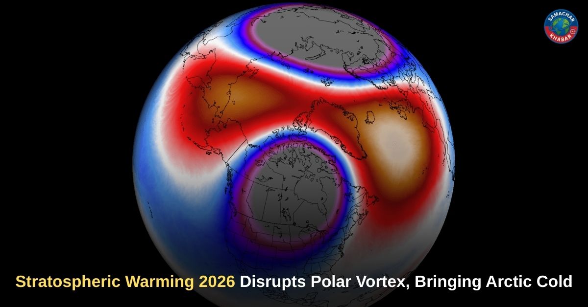
Key Insights from the Stratospheric Warming and Polar Vortex Event 2026
- A strong sudden stratospheric warming (SSW) event is weakening and splitting the polar vortex during mid-February.
- Arctic air has surged into parts of the northeastern United States as circulation patterns shift.
- Atmospheric interference from the Madden-Julian Oscillation (MJO) is temporarily limiting the downward impact of the stratospheric disruption in North America.
- Europe may see colder conditions expand westward as the polar vortex core shifts toward the eastern hemisphere.
- Forecast models suggest colder air could return to parts of the United States and Canada in late February and early March after the temporary warming phase fades.
Understanding the Polar Vortex and Why It Matters
The polar vortex is a large winter circulation of cold air that forms over the polar regions and extends from the lower atmosphere into the stratosphere. When strong, it keeps cold Arctic air contained near the pole, allowing milder conditions across much of the United States and Europe.
However, when disrupted, the vortex can weaken or split, allowing cold air to spill into mid-latitude regions. Meteorologists distinguish between the stratospheric polar vortex, located roughly 10 to 30 miles above the Earth, and lower-level features such as the polar jet stream. While the stratospheric vortex influences large-scale patterns, cold outbreaks at the surface are often delivered through shifts in the jet stream rather than the vortex itself moving south.
This winter, the polar vortex has been weaker than usual, allowing its influence to be felt more frequently in the lower atmosphere.
Mid-February Stratospheric Warming and the Vortex Split
Forecast data shows a significant rise in stratospheric temperatures and pressure during mid-February, a hallmark of sudden stratospheric warming. Such events can increase temperatures in the polar stratosphere by 20 to 40 degrees Fahrenheit within days, slowing the strong winds that normally stabilize the vortex.
As the warming wave intensifies, two high-pressure areas compress the vortex, causing it to elongate and split into separate cores. One portion of the vortex has been displaced toward the eastern hemisphere, while another influence remains connected to North America.
This disruption does not immediately guarantee widespread cold everywhere. The impact depends on how strongly the changes in the stratosphere connect downward into the lower atmosphere.
Arctic Air Outbreaks Across the Northeastern United States

The evolving pattern has already produced a surge of Arctic air across parts of the northeastern United States, including Michigan and Vermont. Extreme cold warnings and advisories have been issued as wind chills drop well below zero.
In Michigan, wind chills have been forecast between 10 and 20 below zero in northern regions, with strong winds and lake-effect snow reducing visibility and creating hazardous travel conditions. Vermont has faced similarly dangerous conditions, with wind chills reaching 20 to 40 below zero in northern and higher-elevation areas.
Meteorologists emphasize that this cold is linked to a lower-level lobe of the polar circulation and shifts in the jet stream rather than the polar vortex itself moving south. The stratospheric warming event has nudged atmospheric patterns, allowing Arctic air to escape temporarily.
Atmospheric Interference: The Role of the Madden-Julian Oscillation
One of the most unusual aspects of this event is the interaction between stratospheric warming and the Madden-Julian Oscillation, a large tropical atmospheric wave that influences global weather patterns.
Forecast models show this tropical disturbance acting as a counter-force in the lower atmosphere, preventing the full downward impact of the stratospheric disruption over North America for a limited period. This interference is expected to bring above-normal temperatures to parts of the central and eastern United States even as the polar vortex weakens overhead.
Meteorologists describe this situation as a rare alignment, where competing atmospheric signals create temporary uncertainty in medium-range forecasts.
Snow and Cold Risks Across the UK and Ireland
Weather models also suggest a potential increase in wintry conditions across parts of the United Kingdom and Ireland during mid-February. Forecast projections indicate snowfall could spread across large areas of the UK as frontal systems interact with colder air, although the extent remains uncertain.
Meteorologists note that a polar vortex split can draw cold easterly air toward western Europe, a setup previously associated with major cold events. Forecast outlooks point to changeable conditions, with rain bands moving northward and snow more likely over higher ground in northern regions.
At the same time, blocking high pressure and Atlantic weather systems may limit how far cold air spreads westward.
Late-Winter Pattern Shift and What Forecasts Suggest Next

Extended-range forecasts indicate that once the influence of the Madden-Julian Oscillation weakens, the connection between the stratosphere and surface weather may strengthen again. This could allow colder air to return to parts of the United States and Canada during the last third of February and into early March.
Temperature trends suggest colder anomalies developing again across western Canada and parts of the eastern United States, while Europe may see cooler conditions expand across larger areas as the vortex core remains displaced toward the eastern hemisphere.
Meteorologists caution that long-range outlooks focus on broad patterns rather than specific daily temperatures, and shifts in pressure systems can still alter outcomes.
Spiritual Perspective: Understanding Natural Changes Through the Unique Knowledge of Saint Rampal Ji Maharaj Ji
While scientific explanations help us understand atmospheric events such as stratospheric warming and polar vortex disruptions, spiritual knowledge offers a broader perspective on the balance of nature and human life. The teachings of Saint Rampal Ji Maharaj Ji emphasize that natural changes remind humanity of the temporary nature of worldly conditions and the importance of living in harmony with divine laws.
His spiritual guidance encourages individuals to seek true knowledge, maintain moral conduct, and develop inner stability so that external changes — whether in weather or life — do not disturb peace and understanding.
A Complex Late-Winter Pattern Driven by Competing Atmospheric Forces
The 2026 stratospheric warming event highlights how interconnected global weather systems can reshape winter conditions across continents. A weakened and split polar vortex, combined with tropical atmospheric interference, has produced a mix of extreme cold, temporary warmth, and uncertain snowfall patterns across the Northern Hemisphere.
While Arctic air has already delivered some of the coldest conditions of the season in parts of the United States, forecasts suggest the overall pattern remains transitional. As atmospheric connections re-establish in the coming weeks, late winter may still bring renewed cold outbreaks and shifting weather conditions across North America and Europe.
FAQs on Stratospheric Warming 2026 and Polar Vortex Disruption
1. What is stratospheric warming and how does it affect weather?
Stratospheric warming occurs when temperatures rise rapidly in the upper atmosphere, weakening the polar vortex and changing jet stream patterns, which can allow Arctic air to move into mid-latitude regions.
2. Is the polar vortex responsible for extreme cold in the United States?
Not directly. Changes in the polar vortex influence the jet stream, allowing Arctic air to spill south, which leads to temporary cold outbreaks across parts of the United States.
3. Why are temperatures above normal in some regions despite polar vortex disruption?
Atmospheric interference from the Madden-Julian Oscillation temporarily blocks the downward impact of stratospheric changes, creating warmer conditions in some areas while cold persists elsewhere.
4. Will Europe experience colder weather after the polar vortex split?
Forecast models suggest colder air may expand westward into parts of Europe as the polar vortex core shifts toward the eastern hemisphere during late February and early March.
5. Does a weakened polar vortex always bring snow and severe winter storms?
No. A weakened polar vortex allows cold air movement, but snowfall depends on moisture and additional weather systems, so cold conditions do not always result in snow or ice.