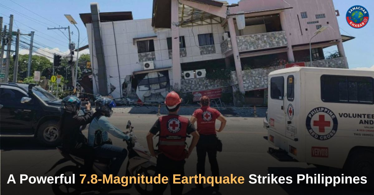
A powerful 7.8-magnitude earthquake struck off the southern Philippines on June 8, killing at least four people, injuring more than 130 others and causing widespread damage to buildings and infrastructure. The offshore quake, centered near General Santos City in Mindanao, triggered tsunami warnings across parts of Southeast Asia and the Pacific region. Authorities ordered immediate evacuations in vulnerable coastal communities, suspended classes in affected areas and launched rescue and assessment operations as strong aftershocks continued to shake the region.
Key Takeaways: Philippines 7.8-Magnitude Earthquake
- A 7.8-magnitude earthquake struck south of General Santos City on June 8.
- At least four people were reported dead.
- More than 130 people were injured in affected areas.
- Tsunami warnings were issued for the Philippines and neighboring countries.
- About 50,000 residents in Kiamba evacuated to higher ground.
- General Santos airport was temporarily closed and flights were canceled.
- Multiple buildings, schools and infrastructure suffered damage.
- Aftershocks measuring up to magnitude 6.5 followed the main quake.
Earthquake Hits Southern Philippines

A 7.8-magnitude earthquake struck the southern Philippines on Monday, June 8, causing fatalities, injuries and structural damage across parts of Mindanao. The earthquake occurred offshore south of General Santos, a city with a population of more than 700,000 people and a major center for tuna processing and commerce.
According to the Philippine Institute of Volcanology and Seismology, the earthquake was caused by movement in the Cotabato Trench. The agency said the quake occurred at a depth of 10 kilometers (6.2 miles). The U.S. Geological Survey later reported the depth at 55 kilometers (34 miles), noting that variations in measurements among agencies are common following major earthquakes.
Numerous aftershocks followed the main tremor. The United States Geological Survey recorded aftershocks of up to magnitude 6.5.
Casualties and Injuries Reported
Authorities confirmed fatalities and injuries as emergency response teams assessed the impact of the disaster.
| Category | Details |
| Magnitude | 7.8 |
| Deaths Reported | At least 4 |
| Injured | More than 130 |
| Largest Aftershock | 6.5 |
| Evacuated Residents in Kiamba | About 50,000 |
| Airport Status | Temporarily Closed |
Police Major Roland Catoburan told AFP that two people died after being crushed by a collapsing wall in Alabel, a municipality near General Santos City.
“We have casualties. A wall fell on them,” Catoburan said.
Master Sergeant Robert Dagon separately confirmed another reported death and four injuries.
The Department of Health later reported that another person died in Davao Oriental province due to the earthquake.
Rod Sosmena, regional director of the Office of Civil Defense, told The Associated Press that at least three people were killed and 130 others injured in General Santos. He said several buildings partially collapsed while infrastructure, including a key access bridge, developed dangerous cracks.
“There were no immediate reports of people being trapped in partially collapsed structures in General Santos,” Sosmena said.
Buildings Collapse as Rescues Continue

Emergency officials reported damage to numerous structures across affected areas.
Videos verified by AFP showed a shopping center containing a Jollibee restaurant reduced to rubble in General Santos City. A school building that officials said was unoccupied also collapsed.
A voice heard in footage of the collapse shouted:
“Lord, it has really collapsed! … The building has really collapsed!”
Robert Dagon said many structures had been affected.
“Many buildings were affected, but I cannot enumerate them now because we are busy with ongoing rescues,” he said.
DZRH radio station reported that a commercial building housing its provincial branch partially collapsed. Employees evacuated safely to the ground floor. Debris from damaged structures also fell onto parked tricycle taxis.
Massive Evacuations Ordered
Philippine President Ferdinand Marcos ordered residents living in vulnerable coastal communities to move immediately to safer locations.
“Move to higher ground now. Do not wait,” Marcos said. “Your life is more important than anything left behind.”
In Kiamba, a coastal town near the epicenter, approximately 50,000 residents evacuated.
Agripino Dacera, the regional disaster chief, said:
“As of now, 80% of the population has moved to higher ground.”
“All the villages along the coast were instructed to proceed to evacuation centres.”
President Marcos also suspended classes in affected areas of Mindanao on what was scheduled to be the first day of school.
“The national government is moving and we will not leave Mindanao behind,” Marcos said.
Tsunami Warnings Spread Across Region
The Pacific Tsunami Warning Center warned that tsunami waves were possible within hours of the earthquake.
The center said tsunami waves could affect coastlines in:
- Philippines
- Indonesia
- Palau
- Taiwan
- Papua New Guinea
The agency later warned that waves reaching up to 3 meters (10 feet) were possible along some Philippine coastlines.
Waves up to 1 meter (3 feet) were possible in Indonesia and Malaysia.
Malaysia’s Meteorological Department issued a tsunami warning for Sabah state on Borneo island.
An 83-centimeter tsunami was recorded off Indonesia’s Sulawesi island.
Smaller sea-level changes were also considered possible in Japan, Papua New Guinea and several Pacific island territories.
Also Read: Meesho and BSE Launch ‘Project Shikhar’ to Help MSMEs Access Public Markets
The Pacific Tsunami Warning Center later lifted an advisory for Guam and stated there was no threat to Hawaii.
Airport Closures and Infrastructure Impact
Authorities temporarily closed General Santos International Airport following the earthquake.
Civil aviation officials reported that 17 domestic flights were canceled.
Several roads, bridges and public facilities sustained damage as engineers assessed structural safety.
Emergency inspections continued across affected regions while authorities restricted access to damaged buildings.
Philippines Remains Vulnerable to Natural Disasters
The Philippines is among the world’s most disaster-prone countries because of its location along the Pacific “Ring of Fire,” an active zone of seismic faults surrounding the Pacific Ocean.
The country regularly experiences earthquakes and volcanic eruptions. It is also struck by about 20 typhoons and tropical storms annually.
Emergency Response Continues Across Mindanao
Rescue teams, disaster-response agencies and local authorities remained deployed across Mindanao following the earthquake. Damage assessments continued while officials monitored aftershocks and tsunami conditions.
Authorities urged residents to follow evacuation instructions and remain alert as emergency operations continued. The earthquake has become the strongest to strike the Philippines this year, leaving communities across southern Mindanao facing significant recovery and rebuilding efforts.
Reflection on Life’s Uncertainty
The earthquake and its aftermath highlight how quickly life can change and how communities often rely on resilience, cooperation and preparedness during times of crisis. Such events also prompt reflection on the value of human life and the importance of remaining calm and responsible in difficult circumstances.
According to the spiritual teachings of Tatvdarshi Sant Rampal Ji Maharaj, true spiritual knowledge encourages individuals to live with awareness, compassion and responsibility while facing the uncertainties of life. These teachings emphasize the importance of inner strength and meaningful living during challenging times.
For more information visit our
Website: www.jagatgururampalji.org
YouTube: Sant Rampal Ji Maharaj
Facebook: Spiritual Leader Saint Rampal Ji
X (Twitter): @SaintRampalJiM
FAQs on Philippines 7.8-Magnitude Earthquake
1. When did the Philippines earthquake occur?
The earthquake struck on June 8, 2026, at 7:37 a.m. local time.
2. How strong was the earthquake?
The earthquake measured 7.8 on the Richter scale.
3. Where was the epicenter located?
The quake was centered offshore southwest of General Santos City in southern Mindanao.
4. How many people were affected?
At least four people were reported dead and more than 130 injured.
5. Were tsunami warnings issued?
Yes. Tsunami warnings and advisories were issued for parts of the Philippines and neighboring regions.